" The river rises at Thames Head in Gloucestershire and flows into the North Sea near Tilbury, Essex and Gravesend, Kent, via the Thames Estuary.
From the west, it flows through Oxford (where it is sometimes called the Isis), Reading, Henley-on-Thames and Windsor.
The Thames also drains the whole of Greater London."
https://en.wikipedia.org/wiki/The_Isis
https://en.wikipedia.org/wiki/River_Thames
"The Thames through Oxford is sometimes called the Isis.
Historically, and especially in Victorian times, gazetteers and cartographers insisted that the entire river was correctly named the Isis from its source down to Dorchester on Thames and that only from this point, where the river meets the Thame and becomes the "Thame-isis" (supposedly subsequently abbreviated to Thames) should it be so called.
Ordnance Survey maps still label the Thames as "River Thames or Isis" down to Dorchester. Since the early 20th century this distinction has been lost in common usage outside of Oxford, and some historians suggest the name Isis is nothing more than a truncation of Tamesis, the Latin name for the Thames. "
"Thames Head Springs (the Isis)
"does not have a fixed location –
rather, it changes according to the level of the groundwater in the limestone.
In dry periods, the groundwater level falls, causing the Thames Head springs to dry up and the river to begin lower down in its course.
In wet conditions, the groundwaters rise and the river can begin at one of the Thames Head springs. During the 2022 United Kingdom heat wave, the source dried up completely, shifting 5 miles (8.0 km) downstream to Somerford Keynes.
From small sources gather vast power.
_____
"Researchers have identified the River Thames as a discrete drainage line flowing as early as 58 million years ago, in the Thanetian stage of the late Palaeocene epoch. "
"Until around 500,000 years ago, the Thames flowed on its existing course through what is now Oxfordshire, before turning to the north-east through Hertfordshire and East Anglia and reaching the North Sea near present-day Ipswich. "
"About 450,000 years ago, in the most extreme Ice Age of the Pleistocene, the Anglian, the furthest southern extent of the ice sheet reached Hornchurch in east London, the Vale of St Albans, and the Finchley Gap."
'It dammed the river in Hertfordshire, resulting in the formation of large ice lakes, which eventually burst their banks and caused the river to divert onto its present course through the area of present-day London."
"The ice lobe which stopped at present-day Finchley deposited about 14 metres of boulder clay there "
"Its torrent of meltwater gushed through the Finchley Gap and south towards the new course of the Thames, and proceeded to carve out the Brent Valley in the process. "
"At the height of the last ice age, around 20,000 BC, Britain was connected to mainland Europe by a large expanse of land known as Doggerland in the southern North Sea Basin. At this time, the Thames' course did not continue to Doggerland but flowed southwards from the eastern Essex coast where it met the waters of the proto-Rhine–Meuse–Scheldt delta flowing from what are now the Netherlands and Belgium. "
"These rivers formed a single river – the Channel River (Fleuve Manche) – that passed through the Dover Strait and drained into the Atlantic Ocean in the western English Channel. "
"Starting in AD 43, under the Emperor Claudius, the Romans occupied England and, recognising the river's strategic and economic importance, built fortifications along the Thames valley including a major camp at Dorchester. Cornhill and Ludgate Hill provided a defensible site near a point on the river both deep enough for the era's ships and narrow enough to be bridged; Londinium (London) grew up around the Walbrook on the north bank around the year 47.
Boudica's Iceni razed the settlement in AD 60 or 61, but it was soon rebuilt; and once the bridge was built, it grew to become the provincial capital of the island."
"The next Roman bridges upstream were at Staines on the Devil's Highway between Londinium and Calleva (Silchester). Boats could be swept up to it on the rising tide, with no need for wind or muscle power. "
"As early as the 1300s, the Thames was used to dispose of waste matter produced in the city of London, thus turning the river into an open sewer. In 1357, Edward III described the state of the river in a proclamation: "... dung and other filth had accumulated in divers places upon the banks of the river with ... fumes and other abominable stenches arising therefrom."
"The growth of the population of London greatly increased the amount of waste that entered the river, including human excrement, animal waste from slaughter houses, and waste from manufacturing processes. According to historian Peter Ackroyd, "a public lavatory on London Bridge showered its contents directly onto the river below, and latrines were built over all the tributaries that issued into the Thames "
"In the late 18th and 19th centuries people known as mudlarks scavenged in the river mud for a meagre living. "
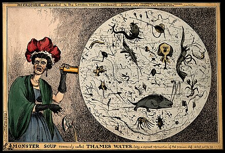
'Satirical cartoon by William Heath, showing a woman observing monsters in a drop of London water (at the time of the Commission on the London Water Supply report, 1828) "
___
"The association between Oxford – rowing, angling – and the Egyptian goddess Isis – might be explained by her role as Stella Maris – "Star of the Sea" ...
"the divine protector of sailors and fishermen".


No comments:
Post a Comment